The Peninsula
Kirwa Village, Lake Karago, Nyabihu
1°38'S 29°31'E · 2,285m
scroll
-1.64382, 29.53002·2,285m
Explore the Site
-1.64382, 29.53002
Elevation 2,285m · Kirwa Village, Nyabihu
How We Found It
We built a terrain analysis pipeline that processed 11.7 million elevation cells across the Rwandan highlands, filtering for sites between 2,000 and 2,600 meters — above the mosquito line, in the volcanic soil belt, with views and space to build.
The pipeline scored every qualifying patch of land across fourteen dimensions: elevation, slope, hilltop prominence, proximity to forest, proximity to water, road access, soil quality, air quality, population density, light pollution, ceramic clay potential, and more.
From 11.7 million cells, it identified 779 qualifying clusters in the Virunga highlands. From those, it ranked 20 candidates. This peninsula was #2 — and when we investigated further, it stood out from everything else.
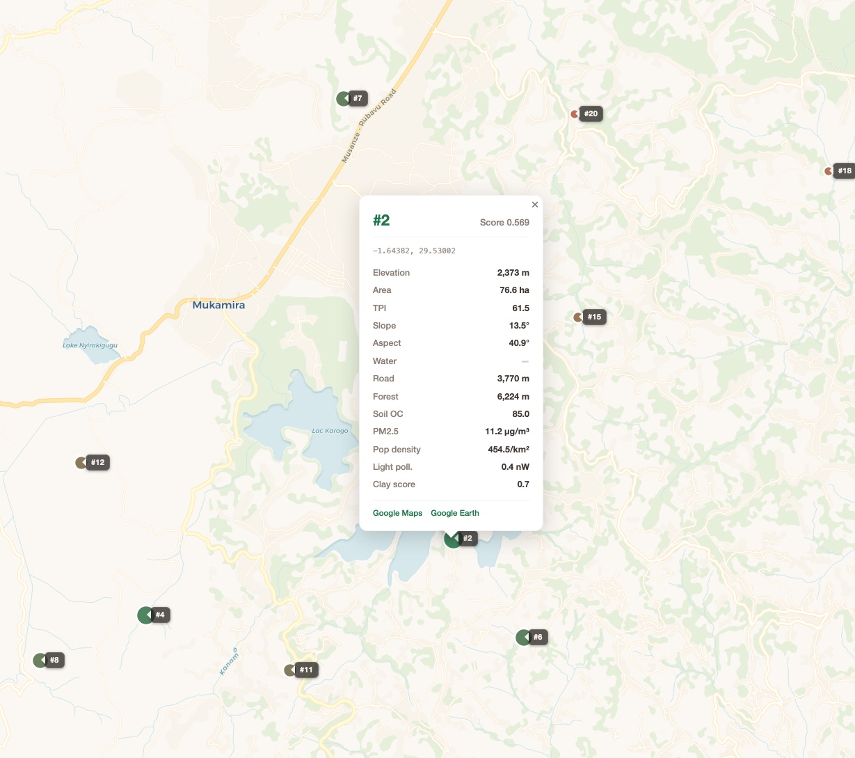
The pipeline's 20 ranked candidates in the Virunga highlands. The peninsula is Candidate #2, on Lake Karago.
The Site
A volcanic promontory — roughly 4 hectares — extending northwest into a small, unnamed highland pond. Bounded by water on three sides. The land across the water to the northwest is unregistered wetland — it cannot be developed, ever. It stays wild.
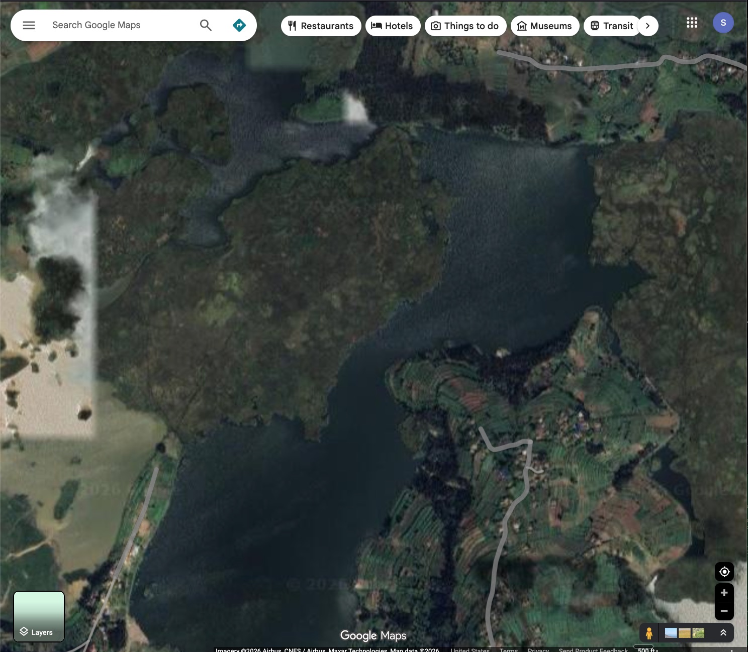
The peninsula from above. Water on three sides. The road arrives from the southeast.
2,285m
Elevation
4 ha
Peninsula Area
85
Soil Organic Carbon
11.2
PM2.5 (µg/m³)
0.4 nW
Light Pollution
0.7
Clay Prospecting
Soil organic carbon of 85 — deep black volcanic andosol — the richest soil in the search zone. Not the red laterite of the south.
PM2.5 of 11.2 — clean air, well below WHO guidelines. The ridgeline position means wind disperses smoke rather than trapping it.
Light pollution of 0.4 nW — essentially zero artificial light. The Milky Way is visible here.
Clay score of 0.7 — strong probability of ceramic-grade kaolinite deposits nearby, from the weathered volcanic geology. This is where the clay comes from.
A Closer Look
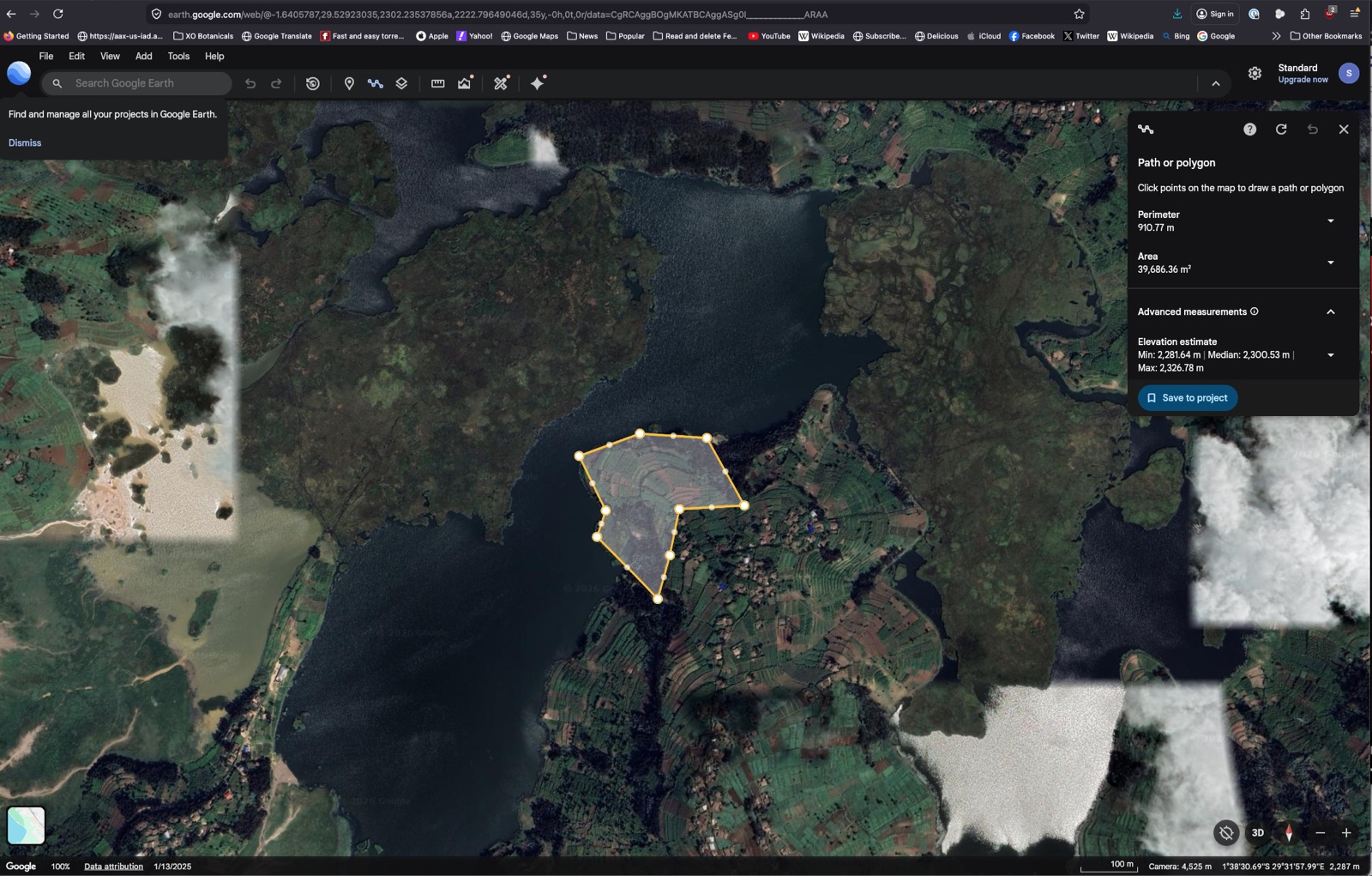
Google Earth measurement: ~39,686 m², perimeter 910m, elevation 2,281–2,327m. The hilltop rises 46 meters above the waterline.
The peninsula's geometry creates natural privacy — water on three sides, a narrow neck connecting to the mainland. The neck is where the entrance goes: a gate, the watchman's shelter, the community charging station. Everything beyond the neck is the compound.
The unnamed pond wraps around the promontory. The far shore is unregistered wetland — permanently wild.
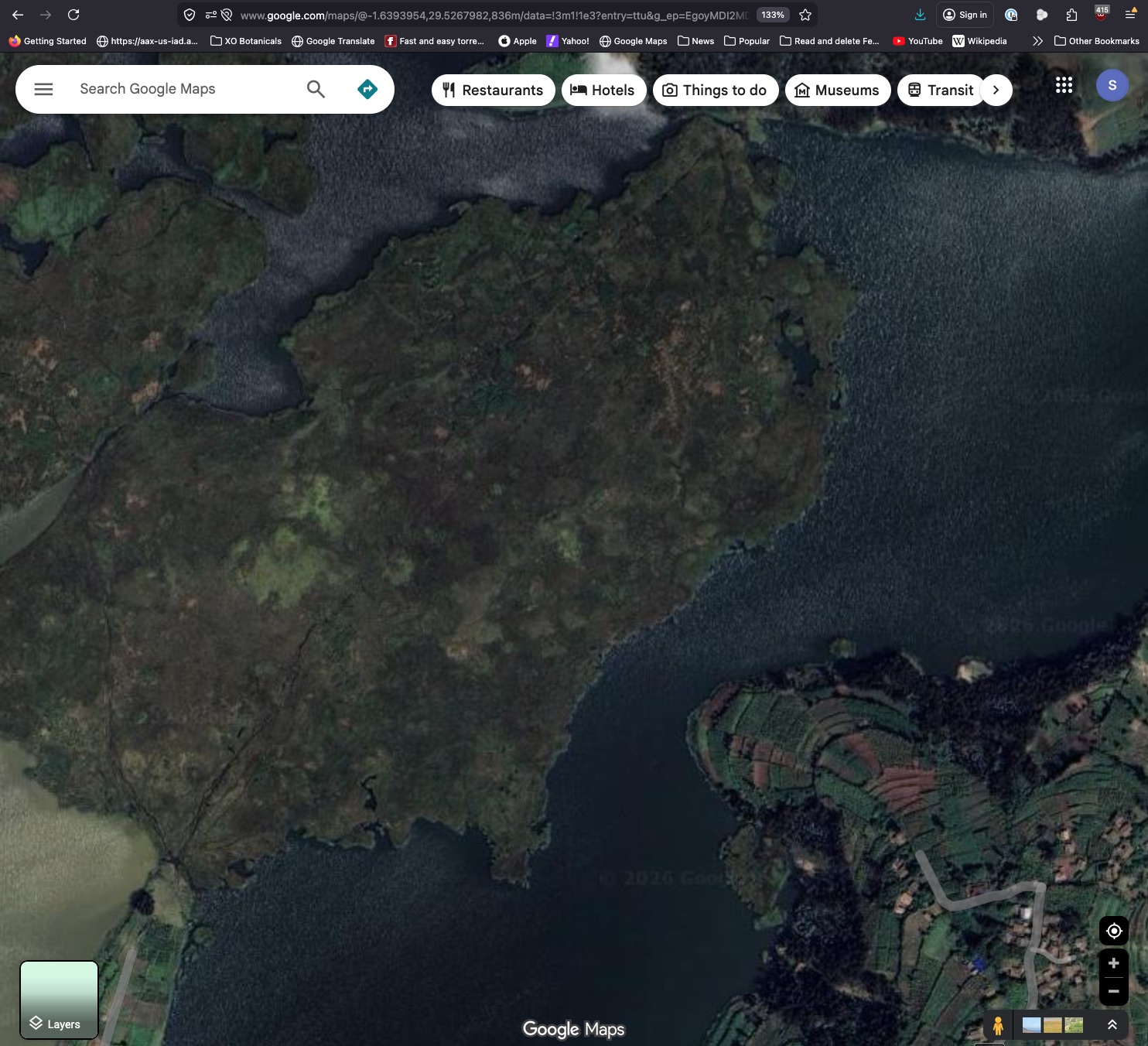
Looking northwest across the water. No structures, no farms. Papyrus, reeds, forest. This view is protected by the land's non-existence in the cadastre.
The Views
We computed line-of-sight visibility from three positions on the peninsula — lake level, mid-slope, and hilltop — tracing 360° of sight lines across 30 kilometers of terrain.
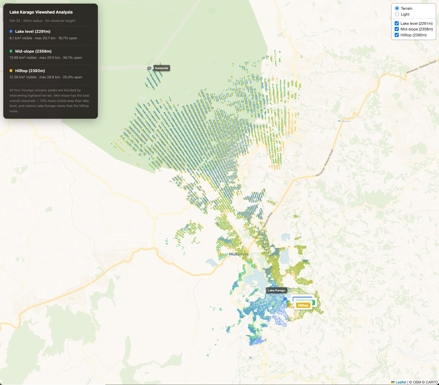
Three viewsheds layered: blue (lake level), green (mid-slope), gold (hilltop). Mid-slope sees the most.
The surprise: Mid-slope (2,358m) is the best building site, not the hilltop. It has 73% more visible area than lake level, retains the water views, and has the broadest horizon (36% open). The hilltop loses the lake entirely because the ridge blocks westward sightlines.
Build at mid-slope. Reserve the hilltop for a treehouse or viewing platform — a place to walk to, not live on.
14 km²
Visible Area (Mid-slope)
29.5 km
Max View Distance
36%
Horizon Openness
The Land
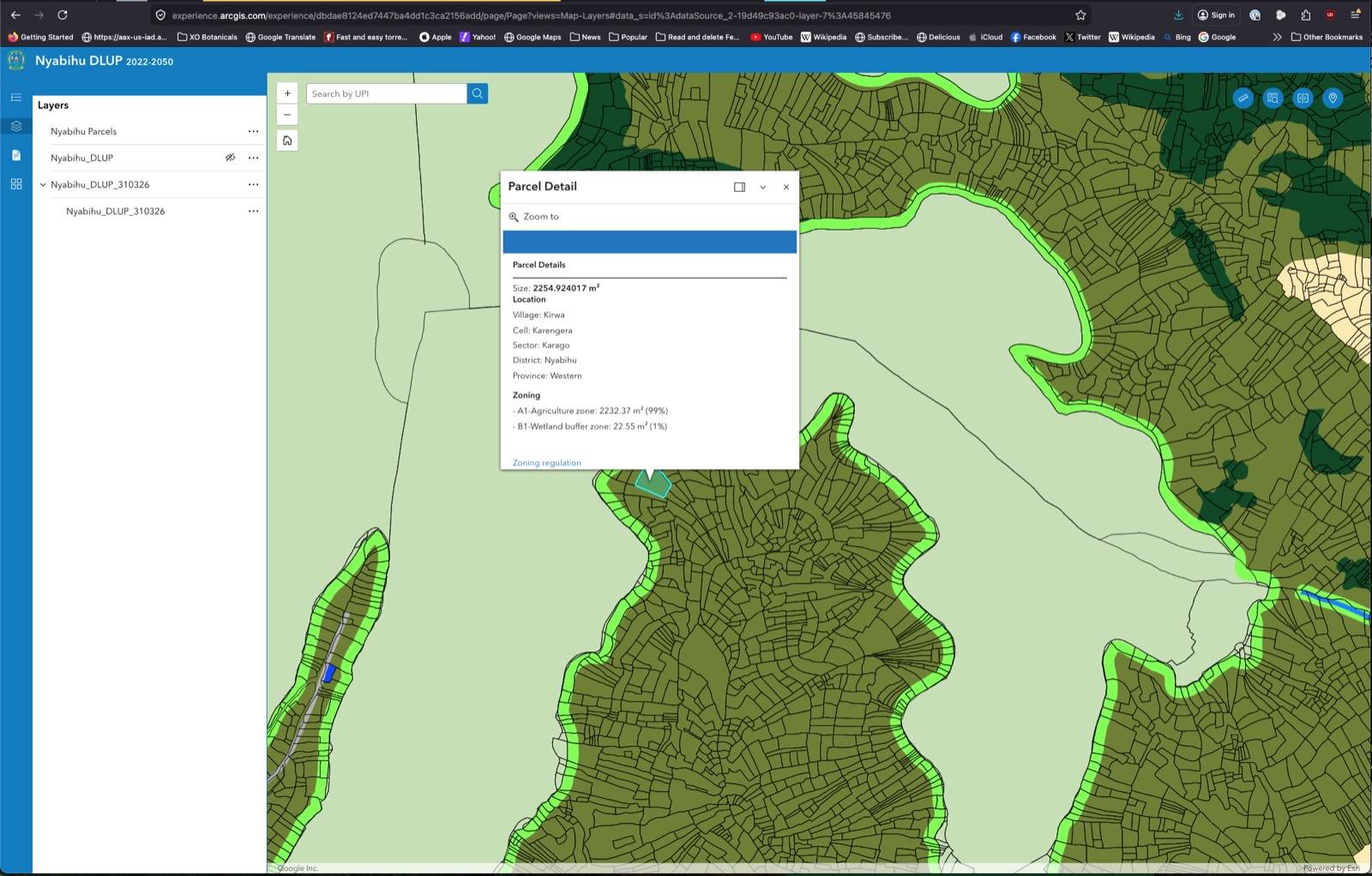
Every parcel in Rwanda is registered, mapped, and classified. The peninsula falls within Karengera Cell, Karago Sector, Nyabihu District. Zoning: A1-Agriculture (99%) with a narrow wetland buffer (1%) along the water's edge.
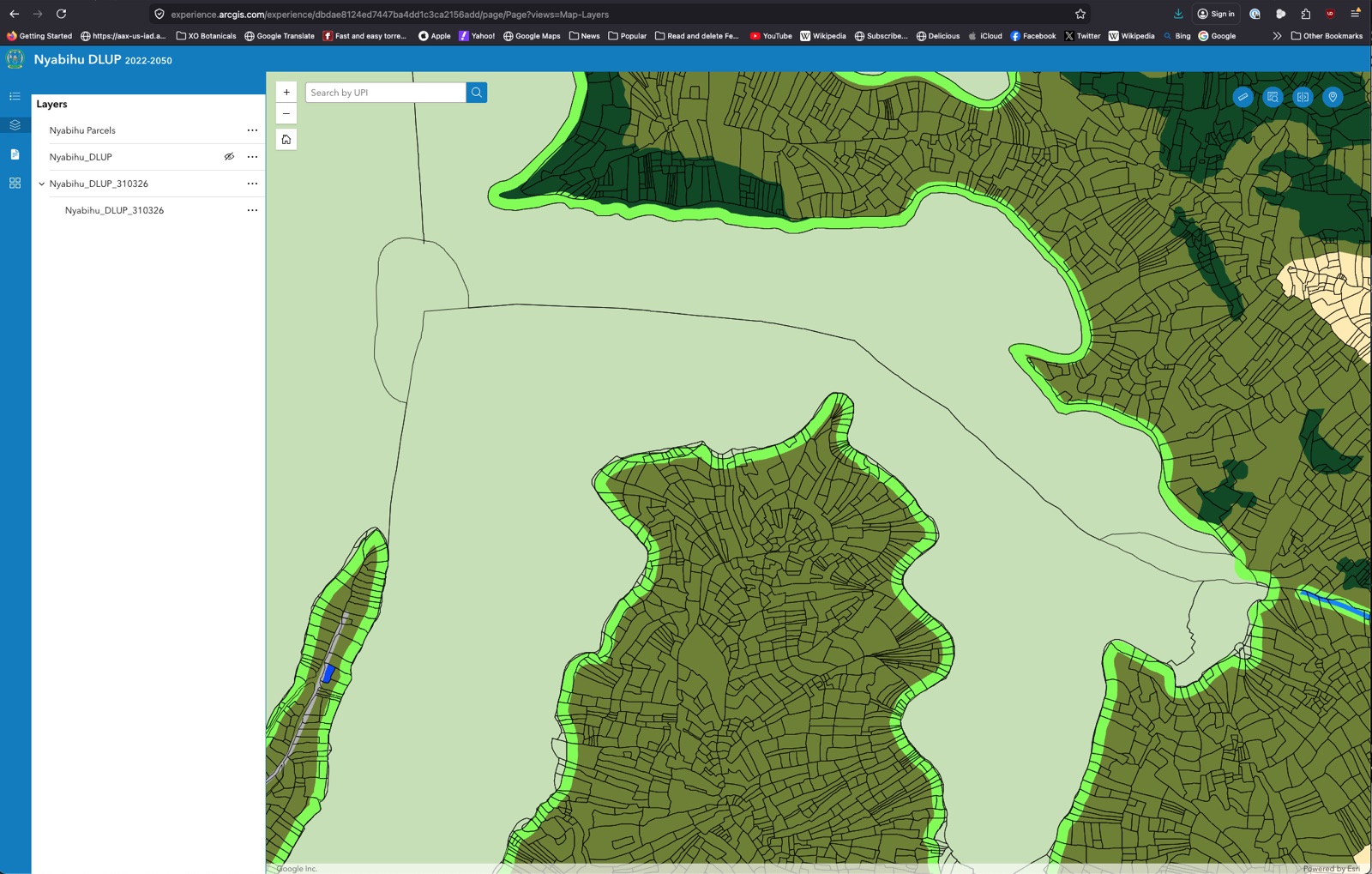
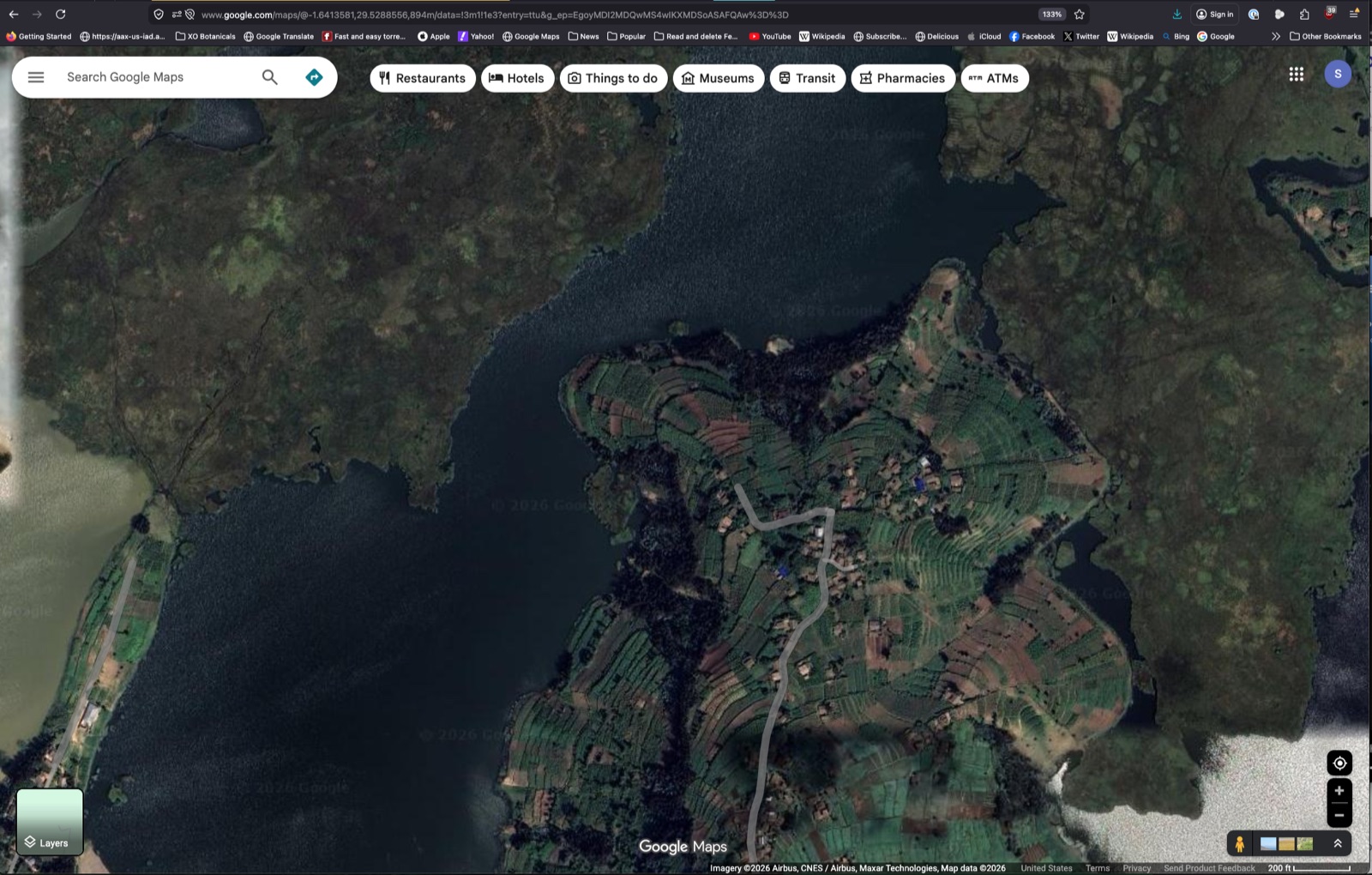
Parcel boundaries on the peninsula. Roughly 80–120 individual plots, averaging 400–500 m² each. Generations of subdivision by farming families.
The Nyabihu DLUP showing the peninsula (dark olive = A1 Agriculture) surrounded by pale areas with no parcel data — water and wetland. The bright green strips are B1 wetland buffer zones along the lake edge.
A1-Agriculture zoning permits a residential homestead, farm buildings, greenhouses, workshops, and agricultural activities. The compound vision — house, ceramics studio, greenhouses, dairy — fits within A1 without requiring a zoning change.
What We Build
The compound unfolds in phases over 4–5 years. We build heavy with local materials — volcanic stone, eucalyptus timber, clay tiles — and import only the technical systems: solar panels, batteries, glass.
Phase 1 — Core (Year 1–2)
| Element | Estimate |
|---|
| Main house — 150–200 m², volcanic stone walls, radiant floor heating, masonry fireplace | $25,000–$45,000 |
| Ceramics studio + kiln room — electric kiln + wood-fired anagama | $14,500–$24,000 |
| Off-grid solar (14 kW) + batteries (60 kWh) + generator | $30,000–$48,000 |
| Rainwater harvesting — ferrocement tanks, filtration | $2,500–$4,500 |
| Site infrastructure — road, fencing, security, composting | $5,000–$9,000 |
| Guest cottage — 40–60 m², initial dwelling during construction | $8,000–$15,000 |
| Phase 1 Total | $85,000–$145,500 |
Phase 2 — Expansion (Year 2–4)
| Element | Estimate |
|---|
| Conservatory — glass + stone, tropical plants, morning coffee | $8,000–$15,000 |
| Natural swimming pond — biofiltered, spring-fed, stone deck | $6,000–$12,000 |
| Sauna / boathouse — wood-fired, lake-edge, plunge pool | $5,000–$10,000 |
| Greenhouses ×3 — lettuces, herbs, experimental | $2,500–$5,000 |
| Golf playground — 3–5 holes, pitch-and-putt through the landscape | $3,000–$6,000 |
| Outdoor living — patio, viewing deck, pizza oven, fire pit | $6,000–$12,000 |
| Agriculture — Jersey cows, mushroom house, orchard, kitchen garden | $6,500–$12,500 |
| Essential oil distillation — pilot operation | $2,500–$6,000 |
| Phase 2 Total | $39,500–$78,500 |
Total Budget
| Category | Estimate |
|---|
| Land assembly (~4 ha, 80–120 parcels) | $100,000–$200,000 |
| Phase 1 + Phase 2 construction | $124,500–$224,000 |
| Phase 3 refinements | $20,000–$40,000 |
| Legal, surveys, contingency | $42,000–$83,000 |
| Total — Full Vision | ~$400,000–$450,000 |
Community
The compound is designed to integrate with the surrounding community, not wall itself off from it.
The compound brings solar electricity to a community that currently has none — a charging station for phones, a WiFi hotspot via Starlink, potentially a clean water point from a developed spring.
6–8 full-time employees: gardeners, caretaker, cook, night watchman, herder, farm hands. At Rwandan wages, that's $10,000–$14,000/year flowing directly into the local economy.
The ceramics studio trains apprentices. The greenhouses supply hotels in Musanze. The essential oil operation creates a new crop for the area. The compound is a node of quiet economic activity embedded in the community, not walled off from it.
See It Yourself
Open the peninsula in satellite view. Zoom in, follow the shoreline, trace the water boundary. On Google Earth, tilt to see the terrain in 3D — the hilltop, the slopes, the neck connecting to the mainland.
What Happens Next
When Winnie visits (June–August 2026)
- Walk the peninsula. Start at the road, walk down to the neck, climb to the hilltop. Stand at mid-slope and look northwest across the water. Take photos in all directions. Note how the light falls. Check soil texture and depth.
- Listen for water. Walk the slopes below the hilltop, especially on the south and east sides. Is there a spring? A seep? Running water that could be developed?
- Meet the neighbors. Talk to the umudugudu chief of Kirwa village. Not a proposal — a conversation. Who lives here? How many families? What do they grow? What do they need?
- Test the water. Ask about whether people fish or swim in this pond. Ask whether anyone has had schistosomiasis. Contact the RBC NTD program about a snail survey.
- Look at the road. Drive from Mukamira to the peninsula. How long does it take? How is the road quality? Could a truck make it in rainy season?
- Visit in the evening. Come back at sunset. Watch the light on the water. Look up after dark. Can you see the Milky Way?
Every number, map, and analysis in this document points to the same next step: a site visit.
The data is strong. Ground truth will determine whether the site is viable.